 When one thinks of Greenland, images of an icebound, harsh and forbidding landscape probably comes to mind, not a landscape of ice pocked ponds and streams transformed into raging rivers. Almost certainly not one that features wildfires.
Yet the latter description is exactly what Greenland looked like according to imagery shared on social media, scientists on the ground and data from satellites.
An extraordinary melt event that began recently continued through the Greenland ice sheet, and there are signs that about 60 percent of the expansive ice cover saw detectable surface melting, including at higher elevations that only rarely see temperatures climb above freezing.
On August 1, the ice sheet saw its biggest single-day volume loss on record, with 12.5 billion tons of ice lost to the ocean from surface melt, according to computer model estimates based on satellite and other data. Records of daily mass loss date back to 1950.
“This model, which uses weather data and observations to build a record of ice and snowfall, and net change in mass of the ice sheet, is remarkably accurate,” says Ted Scambos, a senior researcher at the National Snow and Ice Data Centre (NSIDC) in Colorado. “I would accept the result as fact. 12.5 billion tons lost in one day, and the highest single-day total since 1950,” Scambos said.
July 31 was the biggest surface melt day since at least 2012, with about 60 percent of the ice sheet seeing at least one millimetre of melt at the surface, and more than 10 billion tons of ice lost to the ocean from surface melt.
According to Ruth Mottram, a climate researcher with the Danish Meteorological Institute, the ice sheet sent 197 billion tons of water pouring into the Atlantic Ocean during July.
This is enough to raise sea levels by 0.5 millimetres, or 0.02 inches, in a one-month time frame, said Martin Stendel, a researcher with the institute.
This might seem inconsequential, but every increment of sea-level rise provides a higher launch pad for storms to more easily flood coastal infrastructure, such as New York’s subway system, parts of which flooded during Hurricane Sandy in 2012.
As a result of both surface melting and a lack of snow on the ice sheet this summer, this is the year Greenland is contributing most to sea-level rise.
Thanks to an expansive area of high pressure enveloping all of Greenland — the same weather system that brought extreme heat to Europe last week — temperatures in Greenland have been running up to 15 to 30 degrees above average.
The 2019 extreme melt is compared to a record extreme heat and melt episode that occured in Greenland in 2012. While the extent of surface melt during that event may have exceeded this one so far, the Summit Station experienced warmth that was greater “in both magnitude and duration” during the current event. The temperature only remained above freezing about half as long in 2012, and the peak temperature reached 34.02 degrees this year, whereas it only hit 33.73 in 2012. During the 2012 extreme event, however, 97 percent of the ice surface experienced melting.
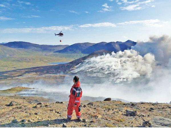
The heat, along with below-average precipitation in parts of Greenland, has even sparked wildfires along the Greenland’s non-ice-covered western fringes. Satellite images and photos taken from the ground show fires burning in treeless areas, consuming mossy wetlands known as fen that can become vulnerable to fires when they dry out. These fires can burn into peat lands, releasing greenhouse gases buried long ago through decomposition of organic matter.
Studies have shown that ice melt periods like the one seen in 2012 typically occur about every 250 years, so the fact that another one is taking place only a few years later could be a sign of how climate change is upping the odds of such events.
According to DMI’s Mottram, the short-term, extreme melt event is a sign of climate change’s increasing influence on the Arctic.