Sri Lanka is a land-limited country with respect to an ever-increasing human population. According to estimates in 2007, out of the total land extent of 6.56 million hectares, 65 percent is allocated for agriculture and, therefore, directly subject to degradation in considerable cases because of mismanagement of the soil resource base. In addition, most other land use activities such as construction of houses and other buildings, roads, and highways, waste, and sewage disposal systems also contribute to severe degradation caused by haphazard soil disturbances.
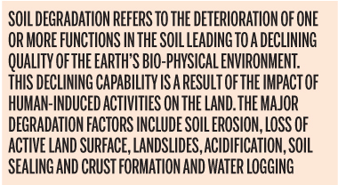
Soil degradation refers to the deterioration of one or more functions in the soil leading to a declining quality of the earth’s bio-physical environment. This declining capability is a result of the impact of human-induced activities on the land. The major degradation factors include soil erosion, loss of active land surface, landslides, acidification, soil sealing and crust formation and water logging. This land degradation, in most cases, ends with adverse ecological, hydrological, environmental, community or human health aftermaths.
In consultation with a Senior Soil Scientist in Canada and a Senior Civil Engineer from Australia, this article is intended to increase awareness of the public regarding important soil related land degradation processes occurring in an accelerated manner in the country. It will also discuss possible and potential aftermaths originating from such degradation, institutional and community responsibilities to address the emerging issues in sustainable manner and the need to implement a disaster management plan for effective mitigation.
Soil erosion
Soil erosion means loss of surface soil by the influence of moving water or wind and occurs in an accelerated manner in exploited lands.
In agricultural fields, most uplands are already degraded due to soil erosion. This physical process has been much more prevalent in the central highlands and rolling to undulating terrain than in the surrounding plains. For example, soil loss due to erosion in marginal tea lands recorded in 2020 at Dolosbage, Gampola was 37.36 tons from one hectare land during one year and in vegetable lands recorded in 2018 at Udawatte, Hanguranketha, it was 50.6 tons from one hectare in a year.
Soil erosion processes reduce land qualities such as soil depth and crop growing potential of uplands in steep terrain, soil fertility, crop yields and quality, floral biodiversity, ground water retention for home gardens, beauty of waterfalls and quality of surface water. Continuation of such adverse changes in these qualities will one day collectively result in a massive ecological aftermath in central highlands in the country.
On the other hand, eroded soil materials get deposited in reservoirs, reducing their capacity for water storage, hydropower generation and crop irrigation in downstream areas. Water soluble constituents in eroded materials such as nitrates and phosphates contribute to pollution of water in reservoir storage. In the past few decades, seasonal occurrence of algal blooms resulting from accelerated eutrophication processes in water in some major tanks provides evidences for this environmental aftermath.
From a conservation point of view, paddy lands in the country have been well protected against soil erosion by establishing irrigation terraces since ancient times. In contrast, uplands exposed to erosion from dry-land farming need the protection of conservation practices in a similar manner.
In urban areas, soil erosion takes place during land development activities such as construction of houses and other buildings, expansion of roads, construction of new roads and highways, and layering of underground power transmission cables and water conveying tubes particularly when commencing earth excavation work during rain spells. Adhering to guidelines already formulated for such earth excavations helps mitigate possible adverse effects.
Loss of active land surface
Loss of active land surface means the net decrease in extent of productive land because of soil erosion or complete earth removal in development activities.
In agricultural fields, farming lands should have minimum of 80 percent surface covered by active soil. Exposure of bed rock and formation of gullies are some examples of the loss of active land surface in the field. This land degradation is a consequence of soil erosion. Measures have been recommended to restore such degraded lands that the public should be made aware of.
In urban areas, complete excavation of earth materials from land parcels for development projects and mining of earth resources such as clay, sand and gem for industries are the most common examples of the loss of active land surface. For instance, sand mining has been reported from streams such as Mahaweli river, Ma Oya and Deduru Oya; gem mining in the Ratnapura and Matale districts; and clay mining at Meetiyagoda. Guidelines are available to ensure scientific and responsible mining of earth resources to minimise localised damage.
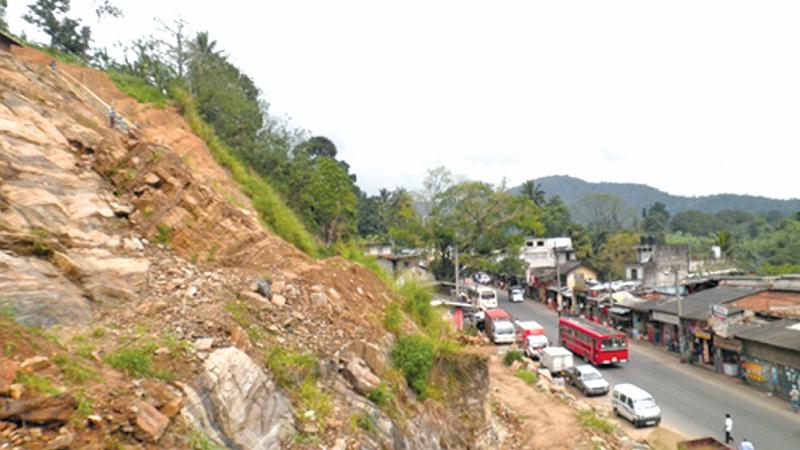
Landslides
Landslides which refer to the mass movement of soil in central hills, are becoming more frequent. They are induced by heavy rains and can remove as much soil as 600 years of surface erosion, yet they have been only a minor factor in land conservation thinking. During heavy rain, the occurrence of landslides is more likely to be linked to underlying geological characteristics than the presence or otherwise of vegetation and soil conservation technologies.
Landslides indiscriminately affect hillside farming and local communities. In addition to the mass movement of soil originating on sloping landscapes, major damages are caused in downstream areas. Many tons of transported sediment are spread over considerable extents resulting in damages to farmland and erected properties such as houses and other buildings.
In addition to making people aware, institutional awareness and involvement is needed to address issues already arisen and take precautionary measures for potential events in future landslide management.
Acidification in soil
Acidification, a process in soil which makes acidic compounds increasingly available to plants and thereby reduces farming potential of the land.
In agricultural lands, the productivity of crops such as tea, potato and exotic vegetable in the upcountry can be adversely affected due to acceleration of acidification processes. In these uplands, frequent soil application of liming materials such as dolomite is recommended and practised by farmers to control this type of land degradation.
With continued liming practices, a considerable fraction of calcium and magnesium released from dolomite gets lost in runoff water into streams. Diversion of such water to the dry zone through engineering structures such as the Polgolla-Ukuwela conduit and the Minipe anicut results a substantial supply of these elements to paddy lands.
According to Sri Lankan scientists, one of the most suspected and proposed causes of the chronic kidney disease of unknown etiology, is the presence of excessive fluoride and magnesium in drinking water. This kidney disease commonly occurs in those who consume well water in the dry zone. Compared to stream water, a 2.5-fold increase of fluoride and magnesium concentration in well water was reported from Girandurukotte in 2016.
Clustered distribution of fluoride measurements in ground water was observed in 2005. A research in 1989 at Pimburattewa near Aralaganwila revealed that the magnesium supply from Mahaweli water to paddy lands was 45 and 68 kilo grams per hectare, during Maha and Yala seasons. This substantial supply of magnesium in Mahaweli water may be a causative factor to this kidney disease leading towards a human health disaster. A clarification research is needed in this regard.
Soil sealing and crust formation
Sealing of soils can be defined as clogging of pores in earth surface with fine soil particles. Crust formation occurs due to the development of a thin impermeable layer on the surface of the earth which results in reduced infiltration, and increased surface runoff. This crust can also reduce the germination and growth of some crops. Frequent soil incorporation of organic matter to enhance earth porosity is recommended to mitigate soil sealing in cultivated lands; additionally, maintaining a grass cover in lands occupied by permanent crops; and establishment of water percolation pits to facilitate water entry into soil.
In urban areas, soil sealing also results from the insulation of earth by artificial materials such as bricks and concrete. This insulation of soil surface with impervious materials cannot be easily removed. It occurs because of various land development activities such as construction of houses and other buildings, tar or asphalt surfacing of roads and vehicle parking sites, stone, or brick construction of garden spaces and concrete linings of city drainage canals.
 These reduce water infiltration and ground water replenishment, generate surface runoff, create surface water ponding and stagnation. These surface sealing practices increase the risk of flooding particularly in the flat terrain. Flooding has been more frequent in municipal areas in cities such as Colombo, Panadura and Ratnapura. Establishment of power-driven drainage systems connected to low lying areas such as ponds, lakes, streams, and the sea help mitigate flood risks. Some potential measures to promote de-sealing of soil in cities include making more room for green areas in the form of parks, playing fields, public gardens, making parking lot surfaces more permeable and encouraging vertical expansion in building erection.
Water logging
Water logging refers to the net increase in soil voids filled with water and is very common in low lying areas.
In agricultural fields, it causes a significant decline in productivity of upland crops. Water logging of soil can be created temporally or permanently due to rising groundwater levels or reducing surface water infiltration due to hydrological changes on the earth at landscape level. Fortunately, rice, the staple crop of the nation, is grown well under waterlogged conditions and, therefore, most of such lowlands are productively used in paddy farming.
Surface flooding
The lower Mahaweli flood prone earth between the Manampitiya railway-bridge and Mutur coast, the largest alluvial deposit in the country, has not been fully used for agriculture due to crop damages from frequent flooding. On the other hand, lower crop yields in the neighbouring Batticaloa district have been due to lack of irrigation water and the fast spread of soil salinity. For example, based on 37-years of yield data from 1979 to 2015, average rice yield in the Batticaloa district remains at 3.0 tons from one hectare land compared to 3.5 tons from one hectare in the Trincomalee district and 4.5 tons from one hectare in the Polonnaruwa district.
Having considered the situations in rice production in the three different districts, the writer suggests a diversion of excess water of Mahaweli river from a suitable location above the Manampitiya railway-bridge to the Maduru Oya basin, and thereafter, to the adjacent small watersheds in the Batticaloa district.
This diversion will be a river basin level water transfer for flood control, crop irrigation, reclamation of saline soils and provision of potable water but will not generate hydropower. This option could minimise frequent flood related hazards in the Polonnaruwa and Trincomalee districts and enhance agricultural production and domestic water supply in the Batticaloa district. This diversion, although costly, could be considered a millennium investment project
Need of a master plan
Soil degradation related aftermaths may lead to human and ecological disasters. Such disasters were very rare and accidental in the past, but today, they are becoming more frequent and predictable. Current management of disasters, event by event is pointless and costly. The increasing frequency of occurrence of these events reveals a need for developing a long-term master plan for the country for implementation with assured domestic funding.
Areas prone to disasters-related soil degradation types such as soil erosion, loss of active land surface, landslides, acidification, soil sealing and crust formation and water logging in exploited lands can be identified, mapped and demarcated. Accordingly, management strategies, implementation procedures, institutional responsibilities and mechanisms to mobilise emergency funds can be formed for ensuring auto functioning of a disaster management program when an emergency arises.
Sri Lanka is a land-limited country and in most cases, the national soil resource base has been mismanaged, particularly in agriculture, urban development, and earth resource-based industries. As a result, soil degradation related land disasters are now more frequent. Hence, development of a disaster management master plan and effective implementation of the formulated plan will ensure a land disasters free environment in the country.
The writer is a Freelance Agriculture Scientist (Natural Resource Management) in Sri Lanka