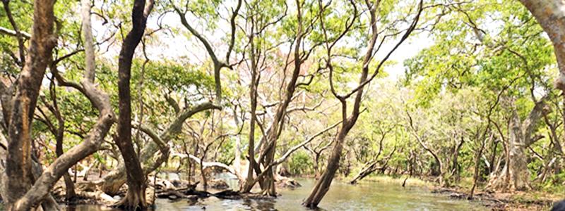
An ancient irrigation canal has changed a dry forest to a wet forest in the remote hinterlands of the Somawathiya National Park. This ‘wet forest’ is recognized as a new forest type, not described or named by any vegetation ecologist in Sri Lanka.
 On the trail of an ancient canal path our tractor commenced the long and arduous journey from the Wildlife Office at the southern end of the Janaranjana Wewa (JW) and rode along the tank bund, descended into stretches of 2-4 feet-deep waters of the Mahaweli outflow areas that feed the JW, climbed on to a tank bund at its far end and finally entered the open plains of the Somawathiya National Park (SNP). This approach is possible only during dry seasons when the flow of the Mahaweli Ganga is low and the depth of wading areas does not exceed 4 feet.
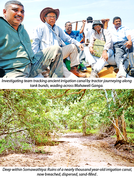 The trailer carried our expedition group of a dozen consisting of the Irrigation Project Staff at Kantale, two officers at JW wildlife office and members of EML - EIA team. The SNP hinterland consisted of a mosaic of habitats or vegetation formations creating a botanical paradise, apparently not yet seen through scientific eyes. Our aim of tracking the ruins of an ancient irrigation canal was so important that we could not afford to stop by too often on this pathless wilderness to admire and delve into the diversity of habitats and ecosystems along the tract.
Large and small Villu Grasslands were an important vegetation type that frequently bordered our path; one of them was over two kilometres in width. The Villu Grasslands have been defined as “wetlands associated with floodplains of the rivers and other water bodies such as shallow seasonal small tanks and long-abandoned paddy fields in the dry zone”. In the SNP areas, they are ecologically important in sustaining large populations of elephants. There were also dense dry forests, technically known as Dry Mixed Evergreen Forests, generally occurring in large patches. For elephants that mostly feed in villus, dense dry forests provide comfortable shade and protection during the hot day. The landscape was mostly open or semi-open scrub vegetation, lacking large trees, technically described as Sparse and Open Forest. There was also an area indicating saline soils, as evident by the presence of some salt-loving trees and shrubs, the Saline Scrub in vegetation ecology. We also encountered the remains of an ancient tank in the midst of this parched hinterland. At present the tank is mostly filled with sand brought in with regular floods and still holds up to half-metre-deep water, even during the dry season, supporting a luxuriant colony of ‘Kumbuk’ trees, presumably providing an oasis for elephants, birds and other animals in this open dry landscape. Dry Riverine Evergreen Forest would be the category of vegetation, if one wishes to classify this interesting vegetation. An extremely interesting find was an area with fire-resistant trees and shrubs, resembling a Savanna. The habitat occurred on highlands (in agricultural terminology) on elevated, dry, non-waterlogged and evidently fire-prone areas, as there were signs of recent bush fires. Proceeding further for another kilometre or so one would come across fine sand expanses, presumably deposited by periodical floods. Finally, the sand-covered canal became apparent and then came somewhat dense forest in which the canal became more evident.
It was well past midday when the group reached the canal. The tractor could not go any further in the dense forest and I had only two hours to botanize the canal and its environs, with the help of my field assistant. A half kilometre walk along the canal and through the forest, which at first sight appeared unique, and I was able to identify almost all plant biodiversity, collect botanical specimens for further research and quantitatively survey the trees and shrubs within two hours. A self-imposed deadline till 3.30 pm to finish all studies and start the return journey was mandatory as wandering in that forest could have been risky due to the presence of many elephants, possibly moving in the late afternoon towards the Mahaweli Ganga, which was only 550 metres east of where we were.
The Somawathiya National Park (SNP), with an extent of 37,762 ha, and along with contiguous Flood Plains National Park (17,350 ha) and Trikonamadu Nature Reserve (25,019 ha) affords protection to a unique habitat, i.e. riverine villus and flood plains etc. as well as to the largest concentration of elephants in the country.
Ancient irrigation canal within Somawathiya
Nearly a thousand year old irrigation canal has been constructed through the Somawathiya during the Polonnaruwa Period to channel water from the Mahaweli Ganga for agriculture. The name of the canal is still unknown and according to the Irrigation Department this ‘Proposed Feeder Canal’ (PFC) of the new irrigation project is 13.6 km long, starting from the upstream intake point at the Mahaweli Ganga and ending at JW, totally located within the SNP in the Polonnauwa District. Today, the distal (northern) half of the canal remains obliterated, covered with sand brought in with regular floods and reclaimed by nature. However, the proximal half (southern), perhaps nearly 7 kilometres, is visible and guarded by the forest. The meandering status of the canal indicates breaching from early stages of its disuse, evidently from 14th Century with the fall of the Kingdom. It was a dug canal without stone reinforcement. The canal was shallow with a depth up to 1 m, often less due to sand deposits, with sporadic stagnant pools of water (during dry seasons).
Ecological influences in the Polonnaruwa Period
The natural ecosystems that existed in the Pre-Polonnaruwa Era and their modifications due to human activities during that period can be sequenced into three phases:
Pre-Polonnaruwa era: It is presumed that about a thousand years ago, this region would have had dry forests dominated by Dry Mixed Evergreen Forest, the typical forest type in the dry zone. Along natural tributaries the river forests (Dry Riverine Evergreen Forests) would have existed. The Savanna Forests also would have existed in appropriate habitats as evidenced by the discovery of plants having Savanna affinities, for example, ‘Et-kukuruman’ and ‘Bu-embilla.’ Therefore, gross reconstruction of the natural vegetation that existed during the Pre-Polonnaruwa era is even possible.
Polonnaruwa Period: During this phase, forest and other natural ecosystems were transformed into a hydrological and agricultural landscape in which large forest areas and other cultivable lands were provided with water requirement founded on a complex and efficient irrigation system to exponentially increase agricultural production. Thus the natural and ‘hostile’ landscapes were transformed into an agricultural, urban, social, religious and cultural scenario in which social prosperity was central. Simultaneously, physical and microclimatic changes in the region resulted in soil-water relations, such as rise of the water table, development of new wetlands such as tanks and rice fields, elevation of atmospheric humidity and amelioration of temperature.
Post-Polonnaruwa era: Since the Kingdom of Polonnaruwa was abandoned in the 14th Century agricultural landscapes were gradually reclaimed by Nature. It is believed that the forests in the dry zone, after clearing for agriculture, e.g. chena cultivation, would eventually recover its original status if left undisturbed. However, this hypothesis has not been realized universally in landscapes of irrigated paddy farming as the latter evidently has brought about physical changes in soil and hydrological features, e.g. rise of water table and development of wetlands and saline habitats.
There are distinct differences between the newly discovered forest (DCEF) and those forests bordering rivers in the dry zone, the Dry Riverine Evergreen Forest (DREF). The DCEF canopies did not exceed 12 to 15 metres in height, while those of river forests were distinctly higher, measuring up to 25 metres and therefore more luxuriant. Furthermore, the river forests (DREF) were dominated by ‘Kumbuk’ trees while canal forests were clearly dominated by ‘Nebada’ trees with ‘Kumbuk’ assuming only a distant second place, as evidenced from quantitative studies.
A river is a natural water course that carries unregulated volumes of water during rainy seasons. The water flow of many small dry zone rivers, during dry seasons, may reach nearly zero level leaving only stagnant pools of water on the river beds. The strong flow during rainy seasons make a river deep, thus creating steep river banks. In contrast, a dug-canal was human-engineered, maintained and regulated during its use and perennial in its water flow. The canal banks were gently sloping instead of being steep.
With the fall of the Polonnaruwa Kingdom in the 14th century, the canal was abandoned and its total agricultural area reclaimed by a succession of natural vegetation, culminating in stable primary state forest and possibly other vegetation formations such as scrub and wetland formations.
The villus of today was possibly the ruins of ancient rice fields. In addition to this hydrological transformation of the landscape, edaphic changes due to inflow and sedimentation of mineral-rich alluvium have made a long-term environmental influence, as indicated by the features of extant vegetation and biodiversity.
Anticipated future trends
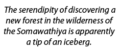
The serendipity of discovering a new forest in the wilderness of the Somawathiya is apparently a tip of an iceberg. The unravelling of antiquities of natural, hydrological, agricultural, social and cultural landscapes of the Polonnaruwa Period should nudge a variety of researchers, particularly archaeologists, historians and naturalists to delve further to unravel new knowledge on the vistas of the past. Evidently, the importance of the Somawathiya National Park will be enhanced by these findings and its custodian, namely the Department of Wildlife Conservation is expected to conserve it diligently for posterity and encourage and coordinate novel research activities within their domain.
(The writer is a Senior Consultant, Former Director, Plant Genetic Resources Centre, Department of Agriculture, Gannoruwa and Former Curator of the National Herbarium, Royal Botanical Gardens, Peradeniya)