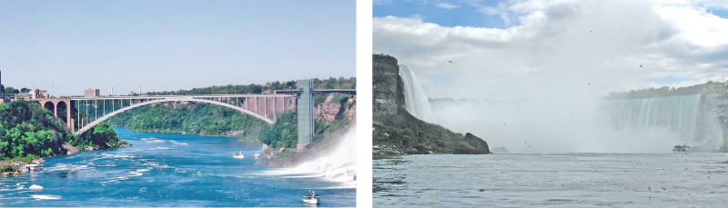
Between the American Falls and the Horseshoe Falls is situated Goat Island in the Niagara River. Queenston Bridge, the Whirlpool Bridge and Rainbow Bridge connects Canada and the USA. One can experience the magnificence of the Falls from the Rainbow Bridge as well.
There are other unique and exciting ways to experience the Falls, like taking an aerial view of Niagara Falls by Niagara Helicopters or aboard the Niagara Sky Wheel located on Clifton Hill. One can also get views of the Falls and beyond as the glass enclosed elevator climbs the outside wall of the Skylon Tower to the Dome, the highest vantage point in Niagara which is 775 feet above the Falls enabling visitors to see 8,000 square miles of Canada and close to USA including skylines of Toronto and Buffalo.
At night the illuminated Falls and the city of Niagara Falls is magnificent and the Winter festival of lights continue from November to January and has over two million lights and is a four season destination. Niagara is truly a remarkable wonder of the world. With sub - zero temperatures every year this natural wonder transforms into a frozen landscape.
Dolomite forms the cliff line of the Niagara Escarpment, over which the Niagara River now flows and forms the Niagara Falls; Goat Island is a small Island located in the middle of Niagara River between Bridal Veil Falls and Horse Shoe Falls.
The Great Lakes and the Niagara – A legacy of the last ice age
The Great Lakes and the Niagara is the result of erosion by Moving Ice. The Great Lakes and the Niagara including the Niagara River and the entire Lakes Basin of which it is a part, is a legacy of the last ice age 18,000 years ago. The Niagara River does not have a V shaped valley, but rather a post- glacial incised valley also created by the last ice age. The Niagara River is a connecting channel between two Great Lakes, Erie and Ontario. The River is about 58 kilometers (36miles) in length and is the natural outlet from Lake Erie to Lake Ontario. The deepest section of the Niagara River is just below the Falls. At Grand Island the Niagara River divides into the West Channel known as Canadian or Chippawa Channel and the East Channel known as the American or Tonawanda Channel. It was about 500 years ago that the river “split” into two channels and thus the Goat Island came to be formed.
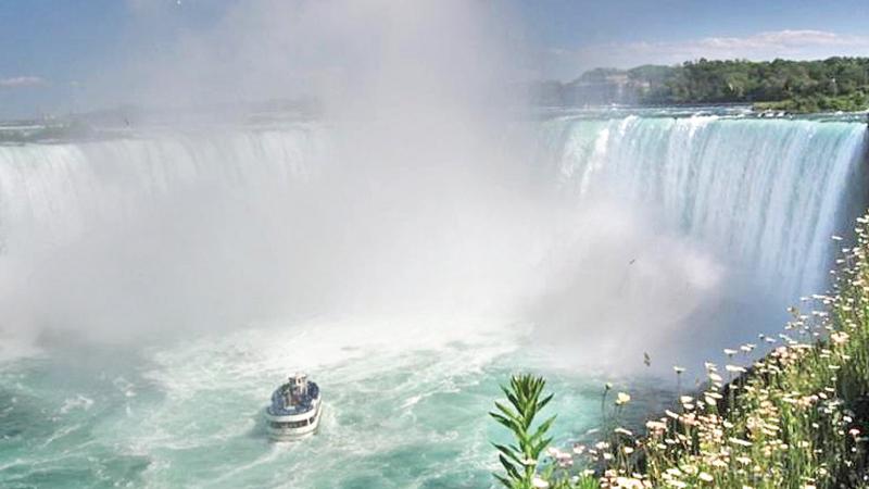
On the Eastern part of the island, the American Falls took shape and on the Western side the Horse Shoe Falls. The Goat Island is named after John Stedman whose goat herds froze to death in the winter of 1780.The American Falls lies between Prospect Point and Luna Island at the left and Bridal Veil Falls between Luna Island and Goat Island at mid left and Canadian Falls between Goat Island and Table Rock. They are collectively called “Niagara falls”. The erosion process is clearly seen at the Niagara Falls, where the river has quickened the process of erosion.
Panoramic view of Goat Island located in the middle of Niagara River between Bridal Veil Falls and Horse Shoe Falls at the right.
The Niagara Escarpment
The Niagara Escarpment is one of the world’s unique natural wonders, stretching 725 kilometres ( 450 miles) covering the Niagara River. In Ontario the escarpment contains more than one hundred sites of geological significance, including exposed rocks and fossils of the Silurian and Ordovician periods, 405 to 500 million years old. The Niagara Escarpment dates back into geological history 430 to 450 million years when the area was under a warm and shallow sea. It is evident that rivers flowed into this ancient sea carrying sand, silt and clay to be deposited in thick layers of sediment. Over millions of years these material became compressed into massive layers of sedimentary rock and ancient reef structures now seen along the escarpment. The Niagara Escarpment is found to be in the shape of a massive horse shoe and traceable from near Rochester, New York, south of Lake Ontario.
With erosion resulting from the action of wind, water and ice, rocks are getting exposed showing encrusted fossil remains of various life forms that existed then.
Great Lakes; Result of Moving Ice
Southern Ontario was covered by ice sheets, two to three kilometres thick. As the ice sheet advanced southwards, they gouged out the basin of Great Lakes. As the ice sheets melted they released vast quantities of melt water into these basins. The Niagara Peninsula became free of water about 12,500 years ago.
As the ice retreated northwards its melt water began to flow down through what became Lake Erie, the Niagara River and Lake Ontario and down to St. Lawrence River and to the Atlantic Ocean. The topography of this area had been constantly changing due to the interplay of geological forces, including alternating retreats and re advances of ice.The Niagara River is a young fresh water system resulting from the ice. The river had exposed rock layers, which is the result of sediments that settled in tropical salt water seas, approximately, 400 to 440 million years ago. These layers of clays, mud, sands and shells were then solidified as sedimentary rock under pressure. These stratified layers are visible from many locations. Fossils of mollusks, fish and corals are also found in the Gorge. The green of the Niagara River has come about as a result of the erosive power of water which causes an estimated 60 tons of dissolved minerals to be swept over the Niagara Falls every minute. The green colour of the water is due to the dissolved salts and very finely ground rock picked up from the limestone bed.
The Niagara Falls is in the Canadian United States border and both in the Province of Ontario and the state of New York and is the second largest, next to Victoria Falls in Southern Africa. In geological terms Niagara River is fairly young, only 12,000 years old.
One fifth of all the fresh water in the world lies in the upper Great Lakes- Michigan, Huron, Superior and Erie. The entire outflow empties into the Niagara River and cascades over the falls and travels 15 miles over many gorges until it reaches the fifth Great Lake-Ontario.
The topography of this area had been constantly changing due to the interplay of geological forces, including alternating retreats and re advances of the ice.
The Canadian Horse Shoe Falls
The Canadian Horse Shoe Falls drops an average of 57 meters (188 ft. ) into the lower Niagara River. More than 168,000 cu.M ( 6 million cu. ft. ) of water go over the crest line of the falls every minute during peak day time.
The crest line of the Canadian Horse Shoe Falls is approximately 670 meters (2,220 ft.) wide. The plunge pool beneath is 35 meters (100 ft.) deep. Goat Island, previously called Iris Island is a small island in the Niagara River, located in the middle of Niagara Falls and Horse Shoe Falls. The Island, at the South West corner of the city of Niagara Falls, is a popular tourist destination for tourists from the American side which provides a spectacular view of the area. It is connected to the US mainland by two bridges and to Luna Island close to the adjacent American Falls. The channel of the Niagara River splits into two above the falls creating two sets of falls, one on either side of the island. Close to Waters Edge and other attractions is Embassy Suites which provides accommodation and other facilities to the visitor among many others in the area.
The writer is a former Director,
Management Consultancy, N.I.B.M