Among the wonderful locations which are filled with natural beauty in Sri Lanka, Shanthipura is considered to be the highest village in the country. Shanthipura is in the vicinity of the Kikiliyamana Hills and is surrounded by tea and vegetable cultivation. The history of the village of Shanthipura, which many visitors to Nuwara Eliya must visit during their visit, is also a bit different.
Shanthipura is five kilometres away from Nuwara Eliya. From Nuwara Eliya Town to Bambarakele on the Kandy road, one can turn left near the Bambarakele temple and take the winding road to Shanthipura. However, vehicles, such as buses, are not allowed on this narrow road because of the sharp curves. For that reason, public transport to the village is operated by minibuses.
This wonderful village is on a slope around the top of Kikiliyamana Hill. The village is over 7,300 feet above sea level. Although the village was established in a valley on a hillside, it seems that the village has later invaded the hill. Mountain forests can be seen above the village. At present there are about 900 families living in this village due to which Shanthipura has seen a massive development.
History
 The surrounding tea estates in Nuwara Eliya were ruled by the British in the 1950s. Although Sri Lanka, or Ceylon as it was known then, gained independence in 1948, the property of the British remained the same. In this background, Shanthipura village was established as a result of a thought which came to the mind of a person named T. William Fernando, who was at that time working for a British-owned tea estate in Nuwara- Eliya. While working for this estate, he formed a small society through which seven landless families were settled in a jungle, which later became Shanthipura.
Fernando, who was immensely respected by the people, was then elected as the Sri Lanka Freedom Party (SLFP) Parliamentarian in the Nuwara Eliya electorate in 1960. As a Parliamentarian, he tirelessly worked to establish Shanthipura in a systematic way and he worked to provide the villagers with facilities such as water and other infrastructure. By 1962, the village was formally established and renamed Shanthipura. Shanthi is said to be his wife’s name. He was also able to pass a bill to establish villages in the central hills at that time. There on, the village of Shanthipura was established in 1962 as an agrarian enterprise.
Current status
At present, Shanthipura residents are mostly dependent on agriculture and vegetable farming has become their main livelihood. Every space in the village has now been used very sparingly for cultivation.
Among the vegetables are carrot, beetroot, cabbage, potatoes and radish. In addition to vegetables, cold-tolerant European flowers are also grown in Shanthipura. Carnation, Rose, Daisy and many other types of flowers are grown in small-scale home gardens.
The highest reservoir in the country is on the top of this hill at the end of Shanthipura village. It is fed by water springs originating from Kikiliyamana mountains and provides water for the cultivation in Shanthipura village. For a long time the villagers got their water from fresh water sources at the edge of their lands. Due to the depletion of water sources in the hills during the past few decades, the village also suffers from water shortages during the dry season.
A visitor centre adjacent to the village called Kalapura, where the village of Shanthipura begins, has recently been built. The centre, which was built with the intention of the tourism industry in the area, is currently managed by the Nuwara Eliya Pradeshiya Sabha. One can climb to the top stage of this viewing centre and see the surroundings.
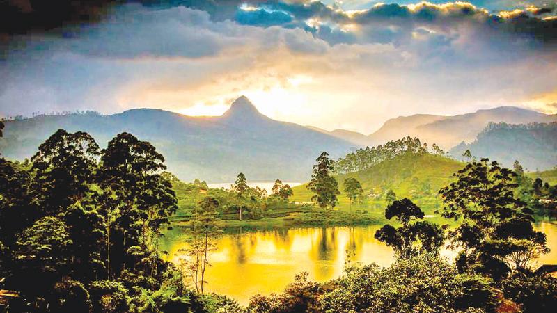
Adam’s Peak is on one side, Pidurutalagala Mountain Range on the other, Nuwara Eliya on the other and Lake Gregory in the distance can be seen from there.
The village ends at the Kikiliyamana Mountain which is the sixth highest mountain in Sri Lanka. Its height is 7,350 feet high from sea level. That means the mountain is a few feet higher than the village. This mountain marks the western boundary of the city of Nuwara Eliya. Today it is not a highland natural forest. A reclaimed forest of pines and eucalyptus. Plants such as maharatmal and keena can be seen in the under planting.
Due to the destruction of these forests for tea cultivation during the time of colonial rule, the unripe forest had been destroyed. The remaining forest around the top of the hill is a reserve belonging to the Department of Forest Conservation. Small mammals and birds can also be seen in the area. The Police Information Centre and Communication Towers are located at the top of Kikiliyamana Hill, while a television broadcasting tower has also been erected.
